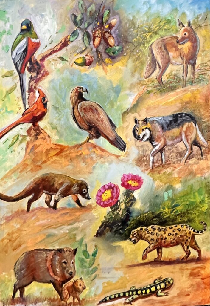
Sky Islands on the Borders of the Sonoran and Chihuahuan Deserts
Carlos Francisco Parra, PhD
Key Concepts
- Santa Cruz County has a unique geography on the border of the United States and Mexico as well as natural borders with the Sky Islands and the Sonoran and Chihuahuan Deserts
- Santa Cruz County’s Sky Islands, such as the Atascosa, Patagonia, and Santa Rita Mountains, are key areas of biodiversity which also nourish the area’s waterways
- The Santa Cruz River for which Santa Cruz County is named begins in the eastern corner of the county, flows south into Mexico, reenters the United States, and flows towards Tucson and the Phoenix area
Key Terms
- Santa Cruz River Valley – the area between the Atascosa and San Cayteano Mountains which includes the Santa Cruz River and the community of Rio Rico
- waterway – stream of water
- Sonoran Desert – an extensive desert located mainly in the Mexican state of Sonora and most of central, western, and southern Arizona with a relatively wetter desert due to its summer and winter storms
- Chihuahuan Desert – North American’s largest desert, defined by its drier, colder climate and higher elevation, including most of northern Mexico, West Texas, New Mexico, and Southeastern Arizona (eastern Santa Cruz County).
- Atascosa Mountains – a rugged mountain range in western Santa Cruz County reaching an elevation of 6,440 feet at Atascosa Peak.
- San Cayetano Mountains – a lower elevation mountain range east of Rio Rico reaching a height of 6,004 feet and named by missionary Padre Eusebio Kino.
- Patagonia Mountains – a chain of mountain south of Patagonia with mineral deposits, walnut, oak, and pine forests, and reaching a height of 7,221 feet. The Patagonias are key crossing for endangered species like the jaguar.
- Santa Rita Mountains – the tallest mountain range in Santa Cruz County, visible from nearly all parts of the region and defined by their biodiversity. The Santa Ritas’ highest points – Mt. Wrightson (9,465 feet) and Mt. Hopkins (8553 feet) – are both in Santa Cruz County. The Madera Canyon Recreational Area is located within the Santa Rita Mountains of Santa Cruz County.
- Sky Island – term used by scientists and conservationists to describe mountains with cooler, higher elevation ecosystems separated from the hotter, drier lower elevation desert environments surrounding them.
- Santa Cruz River – the 184-mile river originating in eastern Santa Cruz County, flowing south into Mexico, reentering the U.S. east of Nogales, and flowing north to its end at the Gila River near Phoenix. Meaning “Holy Cross” in Spanish and referring to the cross carried by Christ during His crucifixion, Santa Cruz County is named after the river.
- Runoff – water flowing down a mountain
- Tributary river – a smaller river which flows into a larger river
- Sonoita Creek – a stream formed as well by runoff from the Patagonia Mountains, flowing between Harshaw, Patagonia and Rio Rico
- Nogales Wash – Also known as the Arroyo los Nogales, this stream forms in what is today Nogales, Sonora, Mexico, crosses into the U.S. via an underground tunnel and is a tributary of the Santa Cruz River. This waterway is highly contaminated.
RESEARCH ARTICLE
A1. What is the Geography of Santa Cruz County?
Sky Islands on the Borders of the Sonoran and Chihuahuan Deserts
Carlos Francisco Parra, PhD
Introduction
Santa Cruz County is one of the most unique counties in the United States. Profoundly defined culturally by its location on the U.S.-Mexican border, Santa Cruz County is a crossroads of peoples, culture, trade and even natural ecoregions such as the Sonoran and Chihuahuan Deserts as well as the Sky Island mountain ranges. The cross-border Santa Cruz River which begins in Santa Cruz County also makes this community a special place in our natural environment. As residents of Nogales, Rio Rico, Patagonia, Sonoita, Tubac in this unique county, we should recognize what makes our borderland county so special so that we can better take care of the land around us.
Human Geography

Armando Moreno (2024), Oil on Canvas
Located along the southern-central portion of the state of Arizona, Santa Cruz County is the smallest county in Arizona by land area. With a surface area of 1,238 square miles and 48,759 residents as of 2022 according to the U.S. Census Bureau, Santa Cruz County is significantly smaller than neighboring Pima County with its 9189 square miles and over 1 million Tucson area residents. All of what is now Santa Cruz County used to be part of Pima County before the Arizona Territorial Legislature created it in 1899 as Nogales became the main port of entry between Arizona and the Mexican state of Sonora. Indeed, before the 1940s, Nogales was the main gateway between the United States and Northwestern Mexico.
For most of Santa Cruz County’s history, the bordertown of Nogales was its largest city and population center. While the county government is still located in Nogales, as of 2020 the largest population center is now the unincorporated suburb of Rio Rico located in the Santa Cruz River Valley, the area including the foothills of the mountains surrounding the Santa Cruz River. According to the 2020 U.S. Census, the population of Nogales was 19,770 residents. However, Rio Rico’s population was larger than Nogales’s for the first time, beating it with 20,549 residents. Reflecting the county’s location on the border, 94.8% of Nogales residents are of Hispanic/Latino ancestry while 87.1% of Rio Rico residents identify as Hispanic/Latino.[1] Santa Cruz County, one of 44 U.S. counties located along the border region with Mexico, is also one of the 179 Hispanic/Latino-majority counties in the United States.[2] Notably, Santa Cruz County isalsoone of Arizona’s two Hispanic/Latino majority counties and has the state’s largest percentage of non-white residents (83.1%).[3]As a whole, Santa Cruz County remains a primarily rural community.
In terms of movement, most residents and visitors of Santa Cruz County move about along two primary transportation corridors – the Interstate 19 corridor which follows the Santa Cruz River Valley north-to-south and Arizona Highway 82 which crosses the county west-to-east from Nogales to Patagonia and Sonoita and eastward towards Sierra Vista and Tombstone in Cochise County. Both of these highways follow waterways (streams of water). Interstate 19 follows the Santa Cruz River between Nogales and Tucson (crossing it near Mission San Xavier just south of Tucson). Highway 82 follows the general route of Sonoita Creek for a good portion of its path from Patagonia to Sonoita. Both of these key highways were built along paths followed by indigenous peoples like the Tohono O’odham who lived in this region. In the 1880s, railroads companies built tracks along Sonoita Creek and later the Santa Cruz River to connect the U.S. with Mexico right through Nogales and Santa Cruz County. Passenger train service in Santa Cruz County ended in 1962, leaving motor vehicles as the main way to move around in this rural county.
Desert Borderlands
Although it receives more water due to its higher elevation, Santa Cruz County is ecologically bordered by two deserts. These are the Sonoran Desert along its western and central areas and the Chihuahuan Desert along the county’s eastern edge near Sonoita and Elgin.

Armando Moreno (2024), Oil on Canvas
The Sonoran Desert is located mainly in the Mexican state of Sonora and most of central, western, and southern Arizona and is considered to be a relatively wetter desert due to its summer and winter storms. The saguaro cactus is the most famous symbol of the Sonoran Desert, but saguaros only grow in remote western corners of Santa Cruz County’s Atascosa Mountains.
On the other hand, the Chihuahuan Desert is a drier, colder, windier, higher elevation desert. It is also North America’s largest desert, including most of northern Mexico, West Texas, New Mexico, and eastern Santa Cruz County. The Chihuahuan Desert’s most famous plants are the yucca, creosote bush, and Mexican fire-barrel cactus. The grasslands of Sonoita and Elgin are typical of the Chihuahuan Desert in Southeastern Arizona. Santa Cruz County’s desert eco-borderlands make this community all the more unique.
Sky Islands
Santa Cruz County’s main waterways are formed by the impressive mountain ranges always in view of local residents. If you look west from Nogales or Rio Rico, a rugged series of low mountains lay before you – the Atascosa Mountains. Also called the Tumacácori Highlands, the Atascosas are so rough that no paved road connects the main population centers of Nogales and Rio Rico with the county’s western part edge. The ghost town of Ruby and Sycamore Canyon, a U.S. Forest Service protected area where many rare tropical birds nest, are located in the Atascosas which reach a height of 6,440 feet at Atascosa Peak.
Looking north from Nogales and east from Rio Rico are the San Cayetano Mountains. Named by missionary Padre Eusebio Kino, the San Cayetano Mountains are a shorter mountain range going only as high as 6,004 feet.[4] The first modern homes in what is now Rio Rico were initially built in the San Cayetano foothills where the now long-lost ghost town of Calabazas was established in 1866 near the present-day Rio Rico Racquet Club along Pendleton Drive. Many unpaved, dead-end roads go up the San Cayetano mountainsides, reminders of the fraudulent real estate origins of modern-day Rio Rico.
Either looking southwards from Patagonia or eastward from Nogales are the massive Patagonia Mountains. The Patagonias reach a height of 7,221 feet and are part of a chain of mountain continuing southward into Mexico but which also have vast deposits of minerals like copper and manganese. The ghost towns of Lochiel, Harshaw, and Washington Camp are reminders of the mining past in the Patagonia Mountains. Although major mining companies seek to develop major operations in them, the Patagonia Mountains are also one of the main corridors used by the endangered jaguars to cross between their habitat in Arizona and their breeding grounds in Sonora. The Patagonia Mountains have walnut, pine, and oak forests, making this range even more remote. The Patagonias are part of the headwaters of the Santa Cruz River which takes its water from the eastside of the mountains.

Jaguar Borderlands: Santa Cruz County
Miguel Grijalva (2024), Oil on Canvas
Continuing north along the wildlands stretching from the Patagonias are the towering Santa Rita Mountains – visible to residents of nearly all parts of Santa Cruz County. Although the northern part of the range is in Pima County, the Santa Ritas’ highest points – Mt. Wrightson (9,465 feet) and Mt. Hopkins (8,553 feet) – are both in Santa Cruz County. It is common to see portions of the Santa Ritas with snow into well into springtime. Forests of oak and pine species define the different slopes of the Santa Ritas from their foothills to their peaks, making the mountains welcoming for javalinas, bobcats, coyotes, deer, and the endangered jaguar. Indeed, several sightings of the rare jaguar, such as “El Jefe,” have been made right in the Santa Ritas. The popular Madera Canyon Recreation Area is a cool and refreshing getaway from the summer heat of the surrounding desert lands.
The Santa Ritas, Patagonias, and Atascosas are called “Sky Islands” by scientists and conservationists. These mountains are called this because at their higher elevations they are islands of cooler ecosystems separated from the hotter, drier lower elevation desert environments surrounding them. The plant, reptile, and mammal biodiversity of the Santa Cruz County Sky Islands is incredible. Other important nearby Sky Islands include the Santa Catalina Mountains near Tucson and the Huachuca Mountains south of Sierra Vista.
Waterways
Santa Cruz County’s Sky Islands are also important for being the primary source of water for our local rivers and arroyos. The county’s most important waterway is the Santa Cruz River. Meaning “Holy Cross” in Spanish and referring to the cross carried by Christ during His crucifixion, the river got its name from the small town of Santa Cruz in Sonora, Mexico, which itself received its name by 1700s Spanish missionaries and troops. The river is the basis of Santa Cruz County’s name and is an incredible American and Mexican river.
The Santa Cruz River is formed by runoff, or water running down, from the Sky Island Patagonia Mountains and Canelo Hills of eastern Santa Cruz County after snow or rainstorms. The river flows south, entering Mexico near Lochiel before passing the historic town of Santa Cruz, Sonora. By San Lázaro, Sonora, the Río Santa Cruz makes a dramatic turn northward and returning into the U.S. east of Nogales through Kino Springs. The Santa Cruz River flows northward fed by tributaries (smaller streams or rivers which flow into a larger river) like the Nogales Wash and Sonoita Creek. The flow continues past Rio Rico, Tumacácori, and Tubac before heading towards Tucson, Casa Grande, and ending just south of Phoenix at the Gila River. The Santa Cruz River is a tributary of the Gila River, while the Gila is a tributary of a much larger river it meets all the way west in Yuma, Arizona – the Colorado River. All water systems are connected in complex ways, reminding us of the ways we are all ultimately connected to one another.
One of the more important tributaries of the Santa Cruz River in our county is Sonoita Creek. Created by Patagonia Mountain runoff, Sonoita Creek emerges just south of the town of Patagonia near Harshaw, flowing northward before turning west towards Rio Rico. During summer rains, Sonoita Creek rages through narrow canyons, emptying into the Santa Cruz River as its tributary near the Rio Rico Racquet Club off Pendleton Road. Most of the year, though, Sonoita Creek’s waters only make it to Lake Patagonia, a recreational lake formed entirely by the creek.
The Nogales Wash or Arroyo los Nogales is another Santa Cruz River tributary. Formed in what is today Nogales, Sonora’s Nuevo Nogales neighborhood, the Nogales Wash draws waters from several arroyos around the Mexican border city. Garbage and sewage waste contaminate the Nogales Wash as it crosses into the United States via a concrete tunnel system underneath the downtown border crossing. The Nogales Wash exits its tunnel near the Nogales City Hall where it runs along a concrete channel. The polluted water is then treated at a chemical plant in Rio Rico which cleans the water and releases it back into the Santa Cruz River to create a permanent surface flow for it.
Many older residents of Santa Cruz County can remember when the Santa Cruz River and Sonoita Creek were year-round waterways with water during each season. Now, water is mainly visible only after summer thunderstorms. Groundwater pumping, along with contamination, are the biggest threats to our surviving rivers. Parts of Nogales, Sonora, are routinely without water supplies due to over pumping and a lack of conservation. Could this be Santa Cruz County someday? Although we all individually have to do our part to conserve our rivers by not throwing trash in them or overusing or water supply at home, the activities with the highest usage of water are agriculture, manufacturing, and mining. These activities are clearly economically vital, but our desert environment requires us to be careful with how we manage our water.
The next time you cross over the Santa Cruz River, or Sonoita Creek, consider how you will shape how the river will look in 5, 10, 20, 100 years. Should we leave trash in dry arroyos? Should we allow excessive use of water? What future do we want for ourselves and the wildlife which depend on the river?
Conclusion
Santa Cruz County possesses a unique natural geography as the border between nations and desert ecoregions. From the Sky Islands to the formation of the Santa Cruz River, and border of two North American deserts, Santa Cruz County vividly demonstrates our community’s natural resources and their interconnection with one another.
Brief Author Bio
Parra is a native Nogalian, former Nogales High School teacher, and an inaugural University of Arizona Presidential Postdoctoral Fellow. Currently he is an Assistant Professor in the University of Arizona Department of History.
[1] “Quick Facts,” U.S. Census Bureau (https://www.census.gov/quickfacts/fact/table/rioricocdparizona,nogalescityarizona,santacruzcountyarizona/POP010220#POP010220)
[2] “The U.S.-Mexican Border Region,” U.S. Dept. of Health of Human Services (https://www.hhs.gov/about/agencies/oga/about-oga/what-we-do/international-relations-division/americas/border-health-commission/us-mexico-border-region/index.html); Katherine Schaeffer, “In a rising number of U.S. counties, Hispanic and black Americans are the majority,” Pew Research Center (Nov. 20, 2019), (https://www.pewresearch.org/short-reads/2019/11/20/in-a-rising-number-of-u-s-counties-hispanic-and-black-americans-are-the-majority/).
[3] https://redistrictingdatahub.org/tools/support/local-redistricting/counties-with-majority-bipoc/
